


Mediterranean to Mt Blanc - a ski traverse of the French Alps
Starting in Menton on 9th Feb and ending in Courmayeur on 12th March this was a journey of 24 stages completed over 32 days. There were eight 'non travel' days. Seven of these were necessitated by bad weather or dangerous snow (four days in Isola 2000, two days in Ref de Rabuons, and one day in Ref Lac de Vens). It rained on the single 'planned' rest day (Montgenvère), therefore we travelled on every possible travel day. The entire distance of 486km was covered on foot or ski without any vehicle use or mechanical uplift. There were two long sections and two short sections where lack of snow necessitated walking: Menton to Col de Turini (43.4km), Valfréjus to Aussois (15.5km), Val d'Isère to le Fornet (4km), and entering / exiting La Thuile (6km). The total distance covered on ski was 417.1km, and the total distance on foot was 68.9km.
Accommodation was mostly in valley hotels and gîtes (a total of 15) ranging from fairly basic to mildly luxurious. Five Refuges were staffed (Nice, Agnel, i Re Magi, Dent Parrachée, Col de la Vanoise). Winter rooms were used in four unguarded Refuges (Merveilles, Rabuons, Lac de Vens, Mario Bezzi). Additionally we used 2 private chalets for single overnight stops. Food, fuel and cooking equipment was carried for use in unguarded huts. Basic glacier travel kit including rope was carried on the more technical sections of the route. Average travel time was 7-9 hrs per day. There were a four 'short' days of 3-4 hrs, and four 'long' days of 10-14 hrs.
I had been contemplating this journey for more than a decade and planned to ski the route last year. I was forced to pull out at short notice and the trip was undertaken by J Kentish and party. In addition to the detailed route planning that I had done previously I was able to benefit from the knowledge gained by this party.
Significant snowfall in the Southern Alps prior to the start gave good snow cover for the first part of the trip and we made good progress during the first week. The second week of the trip was disrupted first by heavy snowfall and then by strong winds. This caused seven days of delay in the Mercantour: four at Isola 2000 and three in the unguarded Rabuons and Vens huts. After this the weather was mostly fair (often hot and sunny) although rising temperatures caused issues in the snowpack on south facing slopes. This became the main hazard during the latter part of the trip and led to increasingly early starts for the longer climbs.
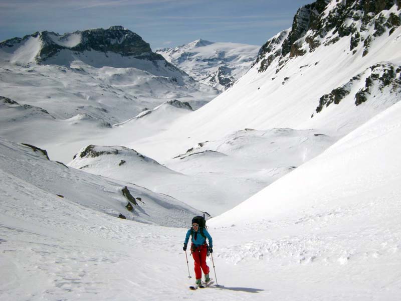
The journey lends itself into being broken down into 4 'natural' sections each of which would make a satisfying ski tour in its own right, although inconvenient start and end points mean that none of these sections could be called 'popular' ski tours. Menton to Isola 2000 follows the GR54 for all but the final few km. The two day hike to the snowline, far from being a chore, was an enjoyable warm up for the journey ahead. The peaks were small scale compared to the mountains further north, but the topography was complex and the passes far from obvious. Huge avalanches had swept some of the steep slopes, and the warden of the Ref de Nice hiked up to the hut to cook dinner for our party of three. Isola 2000 to Larche was the most technical section, requiring roped travel with ice axe and crampons to scale peaks and traverse ridges, but also the most rewarding and enjoyable. Poor weather stretched this four-stage section to seven days with no safe escape options available from the Rabuons or Vens huts.
Larche to Montgenèvre follows the Franco-Italian border closely, skirting the Eastern edge of the Queyras under the watchful gaze of Monte Viso. This is a very enjoyable journey that I had skied before, but unfortunately much of this section was travelled in poor weather and we were denied the views that I had enjoyed previously. With no unwardened huts and no glacier travel the packs were thankfully lighter than on some other sections. Hot showers each night (in Maljasset, Agnel, Abriès) improved the hygiene standards and morale of the team.
Montgenèvre to Val d'Isère is a journey of two halves, and the dividing line is the Maurienne valley. Short days led pleasurably though the Cerces massif via the Clarée and Étroite valleys to Valfréjus (apart from the incident involving getting stuck on a steep forested cliff in sight of the Rif i Re Magi, in a little part of Italy that is now France). The hike from Valfréjus to Aussois via the outskirts of Modane took us past the lowest point on the trip when we crossed the river arc at 1070m, but we did learn about the Maginot line and the French aeronautical testing facility at Avrieux so it was not a wasted day. From Aussois a short climb to the Dent Parrachée refuge set us up for 2 big days: crossing the Glaciers of the Vanoise to the Col de la Vanoise and then onwards to Val d'Isère on increasingly suspect snow. We arrived at both these refuges on their first day of opening, enjoying the convivial company of the wardens and removing the need to carry and cook our own food.
With a good forecast we abandoned plans for a rest day in Val d'Isère and decided to push on to the foot of Mt Blanc at Courmayeur. This was a four-day section with two big days and two shorter days. High temperatures and suspect snow were the main concerns as we put in two days of 1850m ascents crossing the cols of Bailletta, Rhêmes-Golette, Bassac Dere, and Rutor leading to Valgrisenche and La Thuile, separated by a short day and relaxing afternoon at Hotel Perret in Bonne. By the final day we were well into the swing of things: a 5.00am start, a 4km road walk, a 1400m ascent and a steep gully descent to Val Veny seemed like an easy day.
The whole journey was definitely more than the sum of the parts. Skiing northwards for a month enabled us to see winter turn to spring and we grew to appreciate the changing topography of the different mountain ranges. We saw other skiers on only a handful of days, and no more than a few dozen in total. We did all our own routefinding and broke trail for over 90% of the journey in a landscape devoid of skiers or tracks. The trip seemed impossibly long before the start but became quite manageable once we were underway. By the time we reached Courmayeur we had developed a good routine and felt that we could easily continue for another month.
Party: David Hamilton, Venetia Wingfield plus Nick Hellen (days 1-6), Patrick Bird (day 11) and Andre Axelrod (days 23-25). Support vehicle driver, Claire Marvin.
David Hamilton 25/03/2015